Pyg Track, Snowdon: Everything you need to know (Plus map)
Find Out More
Find out more about our walks, courses and events
Page Links

Yr Wyddfa (Snowdon) Daytime Guided Walk
Enjoy the experience of a lifetime and climb Yr Wyddfa (Snowdon), the highest mountain in Wales, and enjoy some of... read more

Snowdon Moonlight Walk
The Snowdon Moonlight Walk is a must-do adventure for anyone seeking an unforgettable experience. Ascend Wales' highest mountain, Yr Wyddfa... read more

Hillwalking Skills Workshop
This weekend is aimed at the people new to hillwalking or who have done a few walks and tailored specifically... read more
11th October 2018

The Pyg Track is the ‘classic’ Snowdon route.
Steeped in history and legend, the Pyg Track attracts many walkers every year wanting to climb Snowdon via this iconic route. Not as busy as the Llanberis Path, the Pyg Track is still one of the Snowdon ‘super-highways’, and one of the most popular routes on Snowdon.
There are many posts and articles online about the Pyg Track, while some are helpful none of them give you enough detail about the route. A lot of the guides have similar information and tips, and we noticed there were a lot of things missing that were key and will make an impact on your walk.
So that’s what we want to do with this post: share with you all the key information that will ensure you have a great experience climbing Snowdon.

About the Pyg Track
The Pyg Track is one of the main walking routes on Snowdon and known as the ‘classic’ route. Short, scenic, steeped in history and with a tough final ascent, this is a fantastic route for both beginners and experienced walkers.
The Pyg Track is the shortest route to the top of Snowdon with the least amount of vertical ascent (but still a tough walk). The Pyg Track is simple to follow and the route is well maintained making this a good route for less experienced hillwalkers.
The scenery on the Pyg Track is possibly the best of any of the other routes which is why this route is so popular.
The Miners Track runs lower down and parallel to the Pyg Track and gives you a slightly different descent (if you want) and takes you down to the impressive Snowdon lakes
Why is it called the Pyg Track?
[su_quote]“Nobody knows for certain why this path is called the Pyg Track. It’s possible that it was named after the pass it leads through, Bwlch y Moch (translated Pigs’ Pass) as the path is sometimes spelled ‘Pig Track’. Or, maybe because it was used to carry ‘pyg‘ (black tar) to the copper mines on Snowdon. Another possible explanation is that the path was named after the nearby Pen y Gwryd Hotel, popular amongst the early mountain walkers.”
Snowdonia National Park Authority.[/su_quote]
Top Tips for the Pyg Track
- There is a car park at Pen-y-Pass which is at the start of the Pyg Track. However, the car park is full by 7am (if not earlier). Unless you arrive extremely early you won’t be able to park. We suggest parking in Nant Peris or Llanberis and using the Sherpa Bus which shuttles people up and down the Llanberis Pass. Google ‘Snowdon Sherpa Bus’
- Avoid parking in the laybys and walking up the Llanberis Pass. It’s dangerous, adds more distance to your walk, and there is a great bus service which will make life easier
- There is one short and very easy rocky section to scramble over. It shouldn’t cause any issues but worth bearing in mind
- The Pyg Track is also the start of the popular Crib Goch scramble. Make sure you stay on the right path!
- If you are planning on climbing Snowdon between March and May then be prepared for snow and ice. The snow can still linger on the upper zigzags well in to Spring. Expect full winter conditions from November to March
- Snowdon is a tough mountain to climb. It has a reputation as being ‘easy ‘and often attracts underprepared walkers. Make sure you are fit, well dressed and prepared for a full day in the mountains. Map and compass are essential for all hillwalkers on all mountains
- Check the weather the day before and the morning of your walk. Use the MetOffice or MWIS. Both have Snowdon specific weather reports
- Stick to your planned route and let someone know where you are going
- Finally, have fun and enjoy Snowdon! The Pyg Track is a fantastic walk
Pyg Track Map and Route

Pyg Track Route Summary
- Difficulty:Moderate – requires a good level of fitness
- Distance:3 miles
- Ascent:750 metres
- Duration:Average 5-7 hours
- Start Location:Pen-y-pass Car Park SH 647 555
- Parking:Pen-y-Pass Car Park postcode: LL55 4NU or in Llanberis (bus)
- Map:OS OL17 Explorer 1:25K
The Pyg Track Route Description
The immense and grand cliffs of Crib Goch and Y Lliwedd loom either side of the Pyg Track as you carve your way towards the vast Snowdon pyramid via the imposing lakes of Llyn Llydaw and Glaslyn.
A final steep zigzagging ascent takes you to the top of the Pyg Track where the route then joins the main Llanberis Path at the ‘finger stone ’for the final few hundred metres to the top of Snowdon.
Pyg Track Ascent
Car parking is available at Pen-y-pass but this can fill up quickly, often by 7am, especially at weekends. We highly recommend parking in Llanberis and taking the Sherpa bus from the village to Pen-y-pass which costs around £1.00 and takes just 15-minutes.
The Pyg Track starts behind the Pen-y-Pass café heading west. You will walk past a wooden post with a blue ‘Pyg Track’ sign as well as a stone marker indicating you are on the correct route.
The path runs alongside Carreg Gwalch heading west directly towards the dominating East Ridge of Crib Goch (this is a tough grade 1 scramble). After 1.5km (1 mile) the path splits below Crib Goch (SH 633 552). Ensure you stay on the Pyg Track route and do not take the stile leading to Crib Goch (this is very well marked).
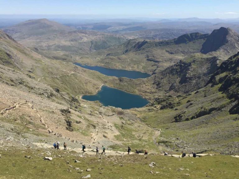
The Pyg Track runs east for the next 2km with the ridge of Crib Goch high above and Llyn Llydaw 200m below. It’s also at this point that the summit of Snowdon can be clearly seen straight ahead (if the weather allows). The route takes you directly through the basin of the Snowdon Horseshoe making for fantastic views of Crib Goch, Y Lliwedd and Crib y Ddysgl (Garnedd Ugain).
The route continues along the Pyg Track through the Cwm with a few easy rocky sections which shouldn’t cause you any difficulties.
You will soon leave Llyn Llydaw behind you and reach the smaller lake of Glaslyn directly under the Snowdon summit. The path will arrive at a standing stone marker (SH 615 548) which indicated the split leading down to the Miners’ Track.
Continue along the Pyg Track which soon becomes more steep! The final sections follow a zigzag route steeply up the mountain with Garnedd Ugain on your right. This section of the route can be challenging in terms of ascent compared to the last few sections so take is slow and save your energy.
The path will emerge at the top and join the main Llanberis Path running alongside the Snowdon Mountain Railway. The path will also be marked with another large standing stone (SH 607 549) known as the finger stone.
This section of the mountain can be busy as the Llanberis, Pyg Track, Miners, Ranger and Crib Goch/Garnedd Ugain routes all intersect for the last few hundred metres to the summit of Snowdon.
Follow the path heading south alongside the railway for the last gradual ascent to the summit.
The path will join a set of steps which will take you to the Snowdon summit.
Congratulations!

Pyg Track and Miners Track Descent
The descent for this guide takes you back to Pen-y-pass via the Miners Track.
You can also head down to Llanberis if you took the Sherpa Bus from the village as the main Llanberis Path will take you directly in to the village and will save you getting the bus back from Pen-y-pass.
Leaving the summit of Snowdon head along the railway for 300m until you reach the large standing market stone indicating a right turn down to the Pyg Track/Miners Track.
Keep an eye out for this marker and as it is often missed when visibility is poor and walkers follow the crowds heading down to Llanberis.

Turning right at the marker stone the Pyg Track steeply ascends down the zigzag path towards Glaslyn.
As you get around halfway alongside Glaslyn the path will split and marked with a large stone. Take the right-hand path leading you down a steep scree slope (take care) reaching the edge of the lake (leaving the Pyg Track). The Miners Path runs around the edge of the Llyn Llydaw and then past some disused mining works.
At the edge of the lake the Miners’ Path (SH 628 545) hugs the shore and meanders around the lake and over the walkway crossing the lake. The route gradual descends and after 1km you will reach the small lake of Llyn Teyrn.
The final 1.5km to the car park at Pen-y-pass is an easy stroll with impressive views of Y Lliwedd behind and the southern slopes of the Glyderau mountains directly ahead.
Final Thoughts
We hope this guide to the Pyg Track helps you plan your Snowdon walk.
Make sure you share any great pictures on the Mountain Walks Facebook Page and also check out our other posts, walks and hillwalking courses.
Enjoy Snowdon!
Further Reading and Information:
- Snowdon Guided Walks: Join one of our group walks
- Snowdon routes: guide to all the Snowdon routes
- Climbing Snowdon: Top tips and advice
This Article is About:
- Snowdon Pyg Track
- Snowdon Pyg Track route map and description
- Snowdon Tips and Advice
- Choosing a route on Snowdon
- Pyg Track and Miners’ Track Snowdon
 Find out more about Mountain Walks and this walk…
Enter your details below and find out more about us, what we do and the events we run. We are always adding new dates, walks and courses so we can let you know what is coming up and what’s new too. Late availability places are also sent out to our subscribers so if you have missed out on a place then we can let you know if one becomes available.
[Formstack id=”3152494″ viewkey=”HgvpvPHPrC” ]